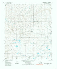
1985 Map of Ikpikpuk River B-1
USGS Topo · Published 1985About this map
The National Petroleum Reserve in Alaska dominates this 1985 survey, revealing a landscape defined by industrial exploration and arctic hydrology. Evidence of the region's energy focus is marked by an Oil Derrick and various Tractor Trails that cross the tundra. The terrain is a network of wandering waterways, including Wolf Creek and Key Creek in the north, and Prince Creek and Maybe Creek toward the southern boundary. A notable feature of the central lowlands is Puddin Lake, surrounded by dozens of unnamed ponds and wetlands. This map provides a detailed look at the infrastructure of the North Slope before modern expansion, capturing specific resource extraction sites like Gravel deposits and a remote Track in an area otherwise devoid of permanent settlements.
Find a feature on this map
11 named features on this map. Tap any name to fly to it.
Don’t see what you’re looking for? This feature index may not catch every label — zoom into the map to look around manually.
Map Details
Editions of this 1985 Ikpikpuk River B-1 Map
This is the sole edition of this map. No revisions or reprints were ever made.
Other maps of this area

1951 · Ikpikpuk River
USGS Topo · 1:250,000

1952 · Umiat
USGS Topo · 1:250,000

1955 · Umiat A-5
USGS Topo · 1:63,360

1955 · Umiat C-5
USGS Topo · 1:63,360

1955 · Umiat B-5
USGS Topo · 1:63,360

1956 · Ikpikpuk River
USGS Topo · 1:250,000

1956 · Umiat
USGS Topo · 1:250,000

1964 · Umiat
USGS Topo · 1:250,000
1984 · Ikpikpuk River A-1
USGS Topo · 1:63,360

1984 · Ikpikpuk River A-2
USGS Topo · 1:63,360