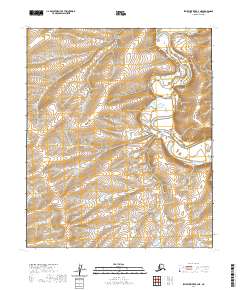
2020 Map of Ikpikpuk River B-4 NE
USGS Topo · Published 2020About this map
Ikpikpuk River meanders across this northern landscape, carving a complex network of oxbows and channels through the North Slope. The terrain is defined by the subtle elevation changes of the Arctic coastal plain, where the river's path has shifted over generations. A significant topographic marker in this area is the Valley of the Willows, which provides a rare named geographical break in the vast, open tundra. This 2020 USGS survey captures the remote character of the region as documented by modern GNIS and National Hydrography datasets. The map relies on Public Land Survey System data from the BLM to define township boundaries such as t2n r13w and t1n r12w, reflecting the systematic grid overlaying this largely untamed wilderness.
Find a feature on this map
8 named features on this map. Tap any name to fly to it.
Don’t see what you’re looking for? This feature index may not catch every label — zoom into the map to look around manually.
Map Details
Editions of this 2020 Ikpikpuk River B-4 NE Map
This is the sole edition of this map. No revisions or reprints were ever made.
Other maps of this area

1951 · Ikpikpuk River
USGS Topo · 1:250,000

1956 · Ikpikpuk River
USGS Topo · 1:250,000
1985 · Ikpikpuk River B-4
USGS Topo · 1:63,360

1985 · Ikpikpuk River B-3
USGS Topo · 1:63,360
1985 · Ikpikpuk River C-3
USGS Topo · 1:63,360
1985 · Ikpikpuk River C-4
USGS Topo · 1:63,360
2013 · Ikpikpuk River C-4 SW
USGS Topo · 1:25,000
2015 · Ikpikpuk River C-4 SE
USGS Topo · 1:25,000
2015 · Ikpikpuk River C-3 SW
USGS Topo · 1:25,000
2016 · Ikpikpuk River B-4 NW
USGS Topo · 1:25,000