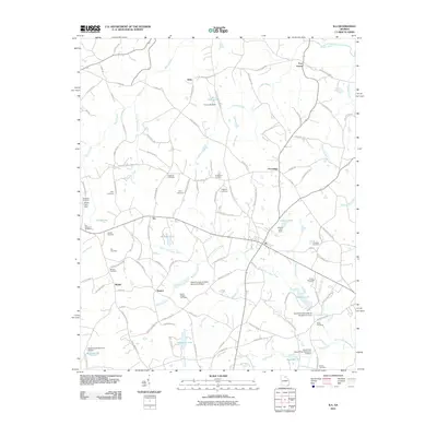
2011 Map of Ila
USGS Topo · Published 2011About this map
Ila serves as the central hub of this Madison County landscape, where the South Fork Broad River and its numerous tributaries like Williams Creek and Kelly Creek carve through the Georgia terrain. The area is defined by a dense network of country roads, including Jot Em Down Rd and Mount Zion Rd, which connect small outlying settlements such as Haggards Crossroad, Alvin, and Pocataligo. Genealogists will find a high concentration of family-named burial sites, such as the Smith-Rogers and McGinnis Cemetery, scattered across the agricultural lots.
Find a feature on this map
120 named features on this map. Tap any name to fly to it.
Don’t see what you’re looking for? This feature index may not catch every label — zoom into the map to look around manually.
Map Details
Editions of this 2011 Ila Map
This is the sole edition of this map. No revisions or reprints were ever made.
Other maps of this area

1891 · Carnesville
USGS Topo · 1:125,000

1954 · Greenville
USGS Topo · 1:250,000

1958 · Greenville
USGS Topo · 1:250,000

1958 · Danielsville
USGS Topo · 1:62,500

1959 · Carnesville
USGS Topo · 1:24,000

1964 · Commerce
USGS Topo · 1:24,000

1964 · Ila
USGS Topo · 1:24,000

1964 · Ashland
USGS Topo · 1:24,000
1964 · Nicholson
USGS Topo · 1:24,000

1964 · Hull
USGS Topo · 1:24,000