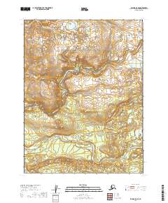
2019 Map of Iliamna A-8 SE
USGS Topo · Published 2019About this map
The Alagnak River serpentines across this southwestern Alaska landscape, serving as the central topographical artery of the region. The river's winding course flows through the protected wilderness of the Katmai National Preserve and the Alagnak Wild River corridor. This 2019 survey documents a vast, undeveloped territory characterized by complex drainage patterns, kettle ponds, and braided water channels typical of the Lake and Peninsula Borough interior. The map illustrates how federal land designations overlap, providing a clear record of administrative boundaries including t12s r39w and t13s r38w. Lacking any roads or established settlements, the area remains an intact representation of the subarctic river systems that define the Bristol Bay watershed.
Find a feature on this map
7 named features on this map. Tap any name to fly to it.
Don’t see what you’re looking for? This feature index may not catch every label — zoom into the map to look around manually.
Map Details
Editions of this 2019 Iliamna A-8 SE Map
This is the sole edition of this map. No revisions or reprints were ever made.
Other maps of this area

1948 · Mt Katmai
USGS Topo · 1:250,000

1951 · Mt Katmai
USGS Topo · 1:250,000

1951 · Mount Katmai D-5
USGS Topo · 1:63,360

1951 · Mount Katmai D-6
USGS Topo · 1:63,360

1951 · Iliamna A-7
USGS Topo · 1:63,360

1951 · Iliamna A-8
USGS Topo · 1:63,360

1952 · Iliamna
USGS Topo · 1:250,000
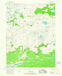
1952 · Iliamna A-8
USGS Topo · 1:63,360

1957 · Iliamna
USGS Topo · 1:250,000

1964 · Mt. Katmai
USGS Topo · 1:250,000