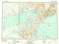
1952 Map of Iliamna
USGS Topo · Published 1955About this map
Iliamna Lake dominates this mid-century landscape, serving as the central hub for the region's isolated settlements and seasonal camps. The map documents the shifting population patterns of the era, noting Old Iliamna while highlighting active centers like Nondalton, Newhalen, and Fish Village. Transportation is defined by water and the occasional Tractor Trail, connecting sites such as Roadhouse and Hedlunds to the shore.
Find a feature on this map
119 named features on this map. Tap any name to fly to it.
Don’t see what you’re looking for? This feature index may not catch every label — zoom into the map to look around manually.
Map Details
Editions of this 1952 Iliamna Map
4 editions found

Other maps of this area

1944 · Kenai
USGS Topo · 1:250,000

1946 · Lake Clark
USGS Topo · 1:250,000

1948 · Mt Katmai
USGS Topo · 1:250,000

1949 · Iliamna C-1
USGS Topo · 1:63,360

1950 · Kenai
USGS Topo · 1:250,000

1950 · Taylor Mountains
USGS Topo · 1:250,000

1951 · Lake Clark
USGS Topo · 1:250,000

1951 · Taylor Mountains
USGS Topo · 1:250,000

1951 · Dillingham
USGS Topo · 1:250,000

1951 · Mt Katmai
USGS Topo · 1:250,000