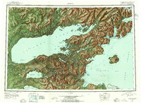
1952 Map of Iliamna
USGS Topo · Published 1955About this map
Lake Iliamna dominates this mid-century reconnaissance, serving as a central hub for small settlements and seasonal camps across the Southwest Alaska interior. The map records a period of transition for native and pioneer communities, noting Old Iliamna (Aband) while showing active sites like Nondalton, Fish Village, and Newhalen. To the southeast, the towering presence of Augustine Island (Volcano) stands in Kamishak Bay, marking the entrance to the wider Cook Inlet waters. Local industry and resources are indicated by Oil Pt on the eastern coast and various camps like Hammersly Camp. The southern edge of the survey borders the Katmai National Monument, illustrating a wilderness shaped by massive freshwater systems like Kukaklek Lake and the Alagnak River. This survey captures the region's transport network before major modern development, relying on water routes through Pile Bay and the Kvichak River.
Find a feature on this map
115 named features on this map. Tap any name to fly to it.
Don’t see what you’re looking for? This feature index may not catch every label — zoom into the map to look around manually.
Map Details
Editions of this 1952 Iliamna Map
4 editions found

Other maps of this area

1944 · Kenai
USGS Topo · 1:250,000

1946 · Lake Clark
USGS Topo · 1:250,000

1948 · Mt Katmai
USGS Topo · 1:250,000

1949 · Iliamna C-1
USGS Topo · 1:63,360

1950 · Kenai
USGS Topo · 1:250,000

1950 · Taylor Mountains
USGS Topo · 1:250,000

1951 · Lake Clark
USGS Topo · 1:250,000

1951 · Taylor Mountains
USGS Topo · 1:250,000

1951 · Dillingham
USGS Topo · 1:250,000

1951 · Mt Katmai
USGS Topo · 1:250,000