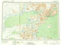
1952 Map of Iliamna
USGS Topo · Published 1953About this map
Iliamna Lake dominates this mid-century reconnaissance, serving as the central hub for a network of subsistence and transport in the Lake Clark and Cook Inlet regions. Several small settlements and seasonal camps dot the shoreline, including Nondalton, Newhalen, and Iliamna, reflecting the established native and settler presence before the era of modern development. To the east, the map captures the transition from the freshwater interior to the tidal waters of Cook Inlet, where the Iliamna Mountains form a formidable barrier broken only by steep passes and coastal indents like Cottonwood Bay and Ursus Cove.
Find a feature on this map
142 named features on this map. Tap any name to fly to it.
Don’t see what you’re looking for? This feature index may not catch every label — zoom into the map to look around manually.
Map Details
Editions of this 1952 Iliamna Map
4 editions found

Other maps of this area

1944 · Kenai
USGS Topo · 1:250,000

1946 · Lake Clark
USGS Topo · 1:250,000

1948 · Mt Katmai
USGS Topo · 1:250,000

1949 · Iliamna C-1
USGS Topo · 1:63,360

1950 · Kenai
USGS Topo · 1:250,000

1950 · Taylor Mountains
USGS Topo · 1:250,000

1951 · Lake Clark
USGS Topo · 1:250,000

1951 · Taylor Mountains
USGS Topo · 1:250,000

1951 · Dillingham
USGS Topo · 1:250,000

1951 · Mt Katmai
USGS Topo · 1:250,000