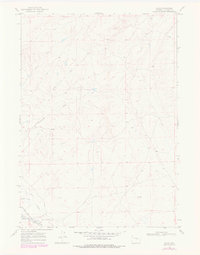
1968 Map of Illco
USGS Topo · Published 1978About this map
Illco serves as the primary point of interest in this high-plains landscape, situated along the Chicago and Northwestern rail line and Thirtythree Mile Road. This map documents a high-desert environment defined by its drainage systems, most notably where the North Fork, Middle Fork, and main channel of Casper Creek converge in the southwest corner. The prevalence of intermittent water features like Smith Draw and North Fork Twentymile Draw reveals a geography dictated by seasonal runoff and sparse reliable water sources such as the lone Spring near the center of the sheet. Survey markers like XBM 5324 and BM 5315 provide exact elevations for genealogists and surveyors looking to locate historical property boundaries or homestead sites near the old railroad right-of-way.
Find a feature on this map
16 named features on this map. Tap any name to fly to it.
Don’t see what you’re looking for? This feature index may not catch every label — zoom into the map to look around manually.
Map Details
Editions of this 1968 Illco Map
2 editions found

Other maps of this area

1950 · Emigrant Gap NE
USGS Topo · 1:24,000

1951 · The Reefs
USGS Topo · 1:24,000

1952 · Bishop
USGS Topo · 1:24,000

1955 · Arminto
USGS Topo · 1:250,000

1955 · Casper
USGS Topo · 1:250,000

1958 · Casper
USGS Topo · 1:250,000

1958 · Arminto
USGS Topo · 1:250,000
1960 · Bishop
USGS Topo · 1:24,000
1960 · Emigrant Gap NE
USGS Topo · 1:24,000
1961 · The Reefs
USGS Topo · 1:24,000