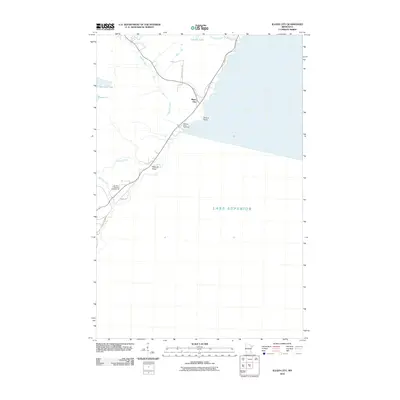
2010 Map of Illgen City
USGS Topo · Published 2010About this map
Illgen City and the rugged shoreline of Lake Superior define this coastal section of Minnesota's North Shore. The geography is dominated by the dramatic elevation changes where the Baptism River descends toward the lake, punctuated by Illgen Falls. Prominent coastal landmarks such as Palisade Head and Shovel Point illustrate the volcanic geology of the region, while the Baptism River Rest Area and Northern Exposure Campground highlight the area's significance for tourism and recreation. Inland, the landscape transitions to a network of small lakes and drainages, including Johnson Lake, Nipisiquit Lake, and Micmac Lake. Transportation patterns are visible through the proximity of modern routes to Old Hwy 61, showing the evolution of the North Shore's primary corridor. Local trails like the G V Trl weave through the forest, connecting the shoreline features to the higher ridges and creek valleys.
Find a feature on this map
20 named features on this map. Tap any name to fly to it.
Don’t see what you’re looking for? This feature index may not catch every label — zoom into the map to look around manually.
Map Details
Editions of this 2010 Illgen City Map
This is the sole edition of this map. No revisions or reprints were ever made.
Other maps of this area

1954 · Silver Bay
USGS Topo · 1:62,500

1954 · Two Harbors
USGS Topo · 1:250,000

1956 · Little Marais
USGS Topo · 1:24,000

1956 · Finland
USGS Topo · 1:24,000

1956 · Finland
USGS Topo · 1:62,500

1956 · Illgen City
USGS Topo · 1:24,000

1956 · Split Rock Point
USGS Topo · 1:62,500

1956 · Split Rock Point NE
USGS Topo · 1:24,000

1957 · Two Harbors
USGS Topo · 1:250,000

1958 · Two Harbors
USGS Topo · 1:250,000