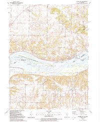
1991 Map of Illinois City
USGS Topo · Published 1992About this map
The Mississippi River forms a complex hydrologic network as it crosses the border between Iowa and Illinois, characterized by a series of significant islands and secondary channels. Along the northern bank in Iowa, the landscape is defined by the steep wooded ravines of Wildcat Den State Park and the structured grounds of the Fairport State Fish Hatchery. The river itself is divided by Geneva Island, Hog Island, and Hershey Island, which create the slow-moving waters of Wyoming Slough and Hershey Slough.
Find a feature on this map
44 named features on this map. Tap any name to fly to it.
Don’t see what you’re looking for? This feature index may not catch every label — zoom into the map to look around manually.
Map Details
Editions of this 1991 Illinois City Map
2 editions found
Other maps of this area

1890 · Durant
USGS Topo · 1:62,500

1891 · Wilton Junction
USGS Topo · 1:62,500

1894 · Durant
USGS Topo · 1:62,500

1901 · Rock Island
USGS Topo · 1:125,000

1901 · Stanwood
USGS Topo · 1:125,000

1910 · Rock Island
USGS Topo · 1:125,000

1916 · Edgington
USGS Topo · 1:62,500

1938 · Edgington
USGS Topo · 1:62,500

1948 · Muscatine
USGS Topo · 1:62,500

1953 · Wilton Junction
USGS Topo · 1:24,000