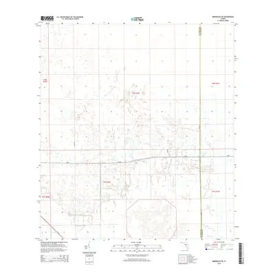
2015 Map of Immokalee NE
USGS Topo · Published 2015About this map
Agricultural development and rural transport networks define this 2015 layout of the interior Everglades transition zone. The landscape is characterized by a precise grid of sections and the Public Land Survey System, specifically marking the junction of Collier and Hendry counties. Significant rural infrastructure is represented by the east-west corridor of CR-846, which cuts across the central wetlands and fields, connecting with local arteries like Thorp Rd and Thomas Farm Rd. In the southwestern corner, SR-29 provides a primary transit link toward the coast. The map illustrates the specialized water management and road networks required for farming in this specific Florida geography, showing the organized parceling of land across several townships, including t46s r30e and t47s r31e.
Find a feature on this map
13 named features on this map. Tap any name to fly to it.
Don’t see what you’re looking for? This feature index may not catch every label — zoom into the map to look around manually.
Map Details
Editions of this 2015 Immokalee NE Map
This is the sole edition of this map. No revisions or reprints were ever made.
Other maps of this area

1956 · West Palm Beach
USGS Topo · 1:250,000

1957 · West Palm Beach
USGS Topo · 1:250,000

1958 · West Palm Beach
USGS Topo · 1:250,000
1958 · Felda SE
USGS Topo · 1:24,000
1958 · Immokalee
USGS Topo · 1:24,000
1958 · Felda
USGS Topo · 1:24,000
1958 · Sunniland
USGS Topo · 1:24,000
1958 · Immokalee NE
USGS Topo · 1:24,000
1958 · Immokalee SW
USGS Topo · 1:24,000
1971 · La Belle 4 SW
USGS Topo · 1:24,000