
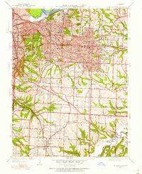
1934 Map of Independence
USGS Topo · Published 1934About this map
Independence serves as the focal point of this 1934 survey, situated at a critical juncture of early 20th-century transportation and municipal growth. The landscape is defined by the winding course of the Blue River and the Missouri River to the north, where heavy rail infrastructure like the Chicago and Alton RR and Missouri Pacific RR meet established roadways like Truman Road and Van Horn Road. This era reveals a transition from rural Jackson County to suburban expansion, evidenced by the numerous small educational and religious centers such as Oldham Sch and Pleasant Grove Ch.
Find a feature on this map
55 named features on this map. Tap any name to fly to it.
Don’t see what you’re looking for? This feature index may not catch every label — zoom into the map to look around manually.
Map Details
Editions of this 1934 Independence Map
2 editions found
Other maps of this area

1887 · Harrisonville
USGS Topo · 1:125,000

1887 · Olathe
USGS Topo · 1:125,000

1890 · Kansas City
USGS Topo · 1:125,000

1892 · Harrisonville
USGS Topo · 1:125,000

1893 · Olathe
USGS Topo · 1:125,000

1894 · Kansas City
USGS Topo · 1:125,000

1894 · Harrisonville
USGS Topo · 1:125,000

1894 · Independence
USGS Topo · 1:125,000

1933 · Blue Springs
USGS Topo · 1:24,000

1934 · Grandview
USGS Topo · 1:24,000