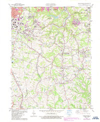
1981 Map of Independence
USGS Topo · Published 1987About this map
Banklick Creek and Fowler Creek carve through the northern Kentucky landscape, defining the topography between the growing suburban corridors of Erlanger and Florence. By the early 1980s, these communities show significant expansion along the Dixie Highway, while the central portion of the map remains anchored by the civic character of Independence. This area is marked by a concentration of local institutions, including the Simon Kenton High Sch, the County Fairground, and the St Cecilias Cem. The geography reveals a transition from industrial and residential density near Covington in the northeast to more open tracts toward Richwood and Walton in the south. Notable local landmarks like Latonia Lakes and the Kenton County Public Park reflect the area's development into a major residential and recreational hub for the region.
Find a feature on this map
71 named features on this map. Tap any name to fly to it.
Don’t see what you’re looking for? This feature index may not catch every label — zoom into the map to look around manually.
Map Details
Editions of this 1981 Independence Map
2 editions found
Other maps of this area

1898 · East Cincinnati
USGS Topo · 1:62,500

1914 · East Cincinnati
USGS Topo · 1:62,500

1914 · West Cincinnati
USGS Topo · 1:62,500

1929 · Alexandria
USGS Topo · 1:48,000

1936 · Alexandria
USGS Topo · 1:62,500

1950 · Union
USGS Topo · 1:24,000

1950 · Independence
USGS Topo · 1:24,000

1950 · Verona
USGS Topo · 1:24,000

1950 · Walton
USGS Topo · 1:24,000

1950 · Covington
USGS Topo · 1:24,000