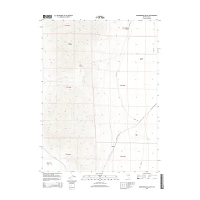
2014 Map of Independence Valley SE
USGS Topo · Published 2014About this map
Pequop Mountains dominate the western half of this Elko County landscape, where Little Lake Pass provides a natural breach between high ridgelines. The transition from these peaks into the Goshute Valley to the east is marked by the historical alignment of the California Trl, which skirts the base of the mountains. This corridor remains a vital transit artery, as seen in the modern infrastructure of Shafter Rd and the Railroad Maintenance Rd that parallel the ancient emigrant path.
Find a feature on this map
20 named features on this map. Tap any name to fly to it.
Don’t see what you’re looking for? This feature index may not catch every label — zoom into the map to look around manually.
Map Details
Editions of this 2014 Independence Valley SE Map
This is the sole edition of this map. No revisions or reprints were ever made.
Other maps of this area

1953 · Spruce Mountain 4
USGS Topo · 1:62,500

1955 · Elko
USGS Topo · 1:250,000

1958 · Elko
USGS Topo · 1:250,000

1962 · Elko
USGS Topo · 1:250,000

1965 · Elko
USGS Topo · 1:250,000

1968 · Independence Valley NE
USGS Topo · 1:24,000

1968 · Independence Valley SW
USGS Topo · 1:24,000
1968 · Independence Valley NW
USGS Topo · 1:24,000

1968 · Independence Valley SE
USGS Topo · 1:24,000
1971 · Hardy Creek
USGS Topo · 1:24,000