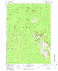
1982 Map of Indian Butte
USGS Topo · Published 1982About this map
Deschutes National Forest spans a landscape dominated by volcanic landforms along the boundary of Deschutes and Lake counties. This 1982 survey illustrates a terrain of numerous cinder cones and ridges, including the prominent Indian Butte and the long Sugar Pine Ridge. The distribution of features like the Indian Spring (Cistern) suggests the scarcity of surface water in this environment, where land use was primarily focused on natural resource extraction and forestry.
Find a feature on this map
17 named features on this map. Tap any name to fly to it.
Don’t see what you’re looking for? This feature index may not catch every label — zoom into the map to look around manually.
Map Details
Editions of this 1982 Indian Butte Map
This is the sole edition of this map. No revisions or reprints were ever made.
Other maps of this area

1931 · Newberry Crater
USGS Topo · 1:125,000

1935 · Newberry Crater
USGS Topo · 1:125,000

1955 · Crescent
USGS Topo · 1:250,000

1957 · Crescent
USGS Topo · 1:250,000

1958 · Crescent
USGS Topo · 1:250,000
1963 · Spring Butte
USGS Topo · 1:24,000
1963 · Paulina Peak
USGS Topo · 1:24,000

1970 · Crescent
USGS Topo · 1:250,000
1974 · Newberry Crater 4 NW
USGS Topo · 1:24,000

1979 · Crescent
USGS Topo · 1:100,000