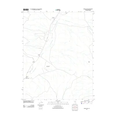
2012 Map of Indian Cove
USGS Topo · Published 2012About this map
Meadow Valley Wash defines the drainage patterns of this high desert landscape in Lincoln County, where seasonal watercourses like Bennett Springs Wash and Miller Spring Wash cut through the terrain. The map highlights a series of isolated outposts and livestock operations, including Mathews Ranch and the uniquely named One Thousand One Ranch. These sites represent the enduring ranching economy of eastern Nevada, where vast distances are bridged by routes such as Hafen Way and Beaver Dam Rd.
Find a feature on this map
15 named features on this map. Tap any name to fly to it.
Don’t see what you’re looking for? This feature index may not catch every label — zoom into the map to look around manually.
Map Details
Editions of this 2012 Indian Cove Map
This is the sole edition of this map. No revisions or reprints were ever made.
Other maps of this area

1885 · Pioche
USGS Topo · 1:250,000

1886 · Pioche
USGS Topo · 1:250,000

1916 · Highland
USGS Topo · 1:62,500

1918 · Highland
USGS Topo · 1:62,500

1921 · NW 1/4 Panaca
USGS Topo · 1:48,000

1954 · Caliente
USGS Topo · 1:250,000

1959 · Caliente
USGS Topo · 1:250,000
1970 · Bennett Pass
USGS Topo · 1:24,000
1970 · Caliente
USGS Topo · 1:24,000
1970 · Panaca
USGS Topo · 1:24,000