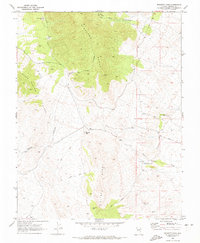
1970 Map of Bennett Pass
USGS Topo · Published 1973About this map
The high desert terrain of Lincoln County is dominated by the intersecting ridges of the Highland Range, Black Canyon Range, and Chief Range. This 1970 survey captures a landscape defined by rugged topography and limited water sources, centered on the strategic crossing at Bennett Pass. Industrial activity is represented by the Pan American Mine in the northwest corner and several Borrow Pits near the higher elevations, indicating the area's history of extraction.
Find a feature on this map
18 named features on this map. Tap any name to fly to it.
Don’t see what you’re looking for? This feature index may not catch every label — zoom into the map to look around manually.
Map Details
Editions of this 1970 Bennett Pass Map
2 editions found
Other maps of this area

1885 · Pioche
USGS Topo · 1:250,000

1886 · Pioche
USGS Topo · 1:250,000

1916 · Highland
USGS Topo · 1:62,500

1918 · Highland
USGS Topo · 1:62,500

1921 · NW 1/4 Panaca
USGS Topo · 1:48,000

1953 · Highland Peak
USGS Topo · 1:24,000

1953 · Pioche
USGS Topo · 1:24,000

1954 · Caliente
USGS Topo · 1:250,000

1959 · Caliente
USGS Topo · 1:250,000
1970 · The Bluffs
USGS Topo · 1:24,000