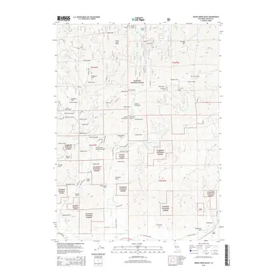
2015 Map of Indian Creek Baldy
USGS Topo · Published 2015About this map
Klamath National Forest dominates this section of Siskiyou County, where the landscape is defined by a dense network of gulches and ridges that shaped early transit and settlement. Historical activity is centered around the Whites Gulch Schoolhouse Gap and the nearby Schoolhouse Gulch, suggesting a pocket of community life amidst the steep terrain. Movement through these canyons followed routes like Indian Creek Rd and McAdams Creek Rd, which parallel the major watercourses. Traces of human presence are scattered throughout the forest, from the high Gunsight Peak to named sites like Baker Cabin Rd and Brownes Cabin. In the southern reaches, the land levels slightly near Moffett Cr, providing space for the Lefko Airport. The variety of gulch names—from New York Gulch to China Gulch—hints at the diverse miners and settlers who once prospected these watersheds.
Find a feature on this map
83 named features on this map. Tap any name to fly to it.
Don’t see what you’re looking for? This feature index may not catch every label — zoom into the map to look around manually.
Map Details
Editions of this 2015 Indian Creek Baldy Map
This is the sole edition of this map. No revisions or reprints were ever made.
Other maps of this area

1886 · Shasta
USGS Topo · 1:250,000

1894 · Shasta
USGS Topo · 1:250,000

1932 · Yreka
USGS Topo · 1:96,000

1939 · Yreka
USGS Topo · 1:125,000

1948 · Weed
USGS Topo · 1:250,000

1950 · Weed
USGS Topo · 1:250,000

1954 · Yreka
USGS Topo · 1:62,500

1955 · Condrey Mtn
USGS Topo · 1:62,500
1955 · Hornbrook
USGS Topo · 1:62,500
1955 · Fort Jones
USGS Topo · 1:62,500