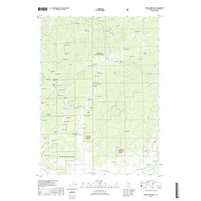
2018 Map of Indian Creek Baldy
USGS Topo · Published 2018About this map
Klamath National Forest dominates this mountain landscape in Siskiyou County, centered on the prominent summit of Indian Creek Baldy. The terrain is characterized by a dense network of gulches and creeks, including Indian Cr, McAdam Cr, and Moffett Cr, which dictate the local topography and historical access routes. Human presence is marked by a series of specialized roads and gaps, such as Baldy Gap and Schoolhouse Gap, the latter named for the local Schoolhouse Gap school. Notable landmarks include the distinctive Gunsight Peak and Soap Creek Ridge to the east. The map reflects a region defined by its drainage patterns and forest management, with features like Steamboat Gulch, Neversweat Gulch, and Whites Gulch suggesting the area's prospecting or early settlement history. This survey provides a clear view of the complex physical geography and public lands within the t44n r9w and t45n r8w townships.
Find a feature on this map
92 named features on this map. Tap any name to fly to it.
Don’t see what you’re looking for? This feature index may not catch every label — zoom into the map to look around manually.
Map Details
Editions of this 2018 Indian Creek Baldy Map
This is the sole edition of this map. No revisions or reprints were ever made.
Other maps of this area

1886 · Shasta
USGS Topo · 1:250,000

1894 · Shasta
USGS Topo · 1:250,000

1932 · Yreka
USGS Topo · 1:96,000

1939 · Yreka
USGS Topo · 1:125,000

1948 · Weed
USGS Topo · 1:250,000

1950 · Weed
USGS Topo · 1:250,000

1954 · Yreka
USGS Topo · 1:62,500

1955 · Condrey Mtn
USGS Topo · 1:62,500
1955 · Hornbrook
USGS Topo · 1:62,500
1955 · Fort Jones
USGS Topo · 1:62,500