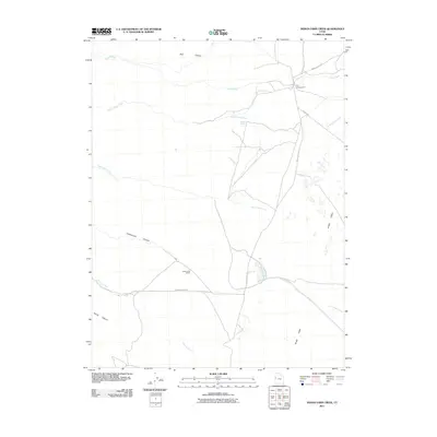
2011 Map of Indian Farm Creek
USGS Topo · Published 2011About this map
Snake Valley serves as the primary corridor through this high desert region of Juab County, where ephemeral water sources and isolated ranching operations define the human presence. Falkenberg Ranch stands as a notable landmark along Granite Creek Rd, positioned near the mouth of Granite Creek. The drainage systems of Indian Farm Creek, Toms Creek, and Red Cedar Creek descend from the west, carving deep incisions such as Dell Canyon and Cottonwood Canyon into the mountain front. Human infrastructure is sparse, concentrated primarily along the Snake Valley Rd and the Weiss Hwy. The presence of the CCC Campground near the northern boundary and Kent Spring highlights the historical importance of developed water and public land management in this arid landscape.
Find a feature on this map
14 named features on this map. Tap any name to fly to it.
Don’t see what you’re looking for? This feature index may not catch every label — zoom into the map to look around manually.
Map Details
Editions of this 2011 Indian Farm Creek Map
This is the sole edition of this map. No revisions or reprints were ever made.
Other maps of this area
1908 · Fish Springs
USGS Topo · 1:250,000
1910 · Fish Springs
USGS Topo · 1:250,000

1953 · Delta
USGS Topo · 1:250,000

1958 · Delta
USGS Topo · 1:250,000
1960 · Granite Mountain
USGS Topo · 1:62,500
1961 · Trout Creek
USGS Topo · 1:62,500

1962 · Delta
USGS Topo · 1:250,000
1972 · Mud Lake Reservoir
USGS Topo · 1:24,000
1972 · Ibapah Peak
USGS Topo · 1:24,000
1972 · Goshute Canyon
USGS Topo · 1:24,000