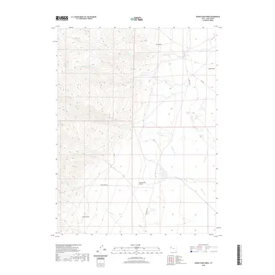
2020 Map of Indian Farm Creek
USGS Topo · Published 2020About this map
Pony Express Rd cuts through this high desert corridor, following a route steeped in the history of the American West. The landscape is defined by the drainage systems of Indian Farm Cr and Red Cedar Cr as they flow toward the broad expanse of Snake Valley. The presence of Kent Spring highlights the critical importance of water sources in this arid environment, often serving as the primary reason for historical travel and camp locations. To the south, Horse Canyon and Cottonwood Canyon provide deep relief in the terrain. For the modern researcher, the alignment of the Pony Express Rd alongside Weis Hwy and Granite Creek Rd offers a clear view of how early transport paths became the foundation for contemporary access in Juab County.
Find a feature on this map
12 named features on this map. Tap any name to fly to it.
Don’t see what you’re looking for? This feature index may not catch every label — zoom into the map to look around manually.
Map Details
Editions of this 2020 Indian Farm Creek Map
This is the sole edition of this map. No revisions or reprints were ever made.
Other maps of this area

1908 · Fish Springs
USGS Topo · 1:250,000

1910 · Fish Springs
USGS Topo · 1:250,000

1953 · Delta
USGS Topo · 1:250,000

1958 · Delta
USGS Topo · 1:250,000

1960 · Granite Mountain
USGS Topo · 1:62,500

1961 · Trout Creek
USGS Topo · 1:62,500

1962 · Delta
USGS Topo · 1:250,000

1972 · Mud Lake Reservoir
USGS Topo · 1:24,000
1972 · Ibapah Peak
USGS Topo · 1:24,000
1972 · Goshute Canyon
USGS Topo · 1:24,000