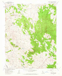
1962 Map of Indian Gulch
USGS Topo · Published 1963About this map
Mining and ranching life defines this 1962 landscape in the foothills of Mariposa County, where the historic Indian Gulch settlement and the Toledo (Site) represent early California habitation patterns. The map documents a rugged terrain dominated by Quartz Mountain and Santa Cruz Mountain, with evidence of small-scale industry at the Ruth Pierce Mine and Owl Mine. Local community history is preserved through the locations of the Hornitos Sch and multiple burial grounds like Gulch Cem and Santa Cruz Cem. The hydrology of the area is well-charted, showing the path of Burns Creek and the formation of the Owens Reservoir to the south. This topographical record, produced in cooperation with the California Department of Water Resources, captures a transitional era of land management before more modern development altered the rural character of the foothills.
Find a feature on this map
39 named features on this map. Tap any name to fly to it.
Don’t see what you’re looking for? This feature index may not catch every label — zoom into the map to look around manually.
Map Details
Editions of this 1962 Indian Gulch Map
This is the sole edition of this map. No revisions or reprints were ever made.
Other maps of this area

1893 · Sonora
USGS Topo · 1:125,000

1896 · Sonora
USGS Topo · 1:125,000

1897 · Sonora
USGS Topo · 1:125,000

1898 · Sonora
USGS Topo · 1:125,000

1915 · Owens Creek
USGS Topo · 1:31,680

1916 · Merced Falls
USGS Topo · 1:24,000

1918 · Owens Creek
USGS Topo · 1:31,680

1918 · Planada
USGS Topo · 1:31,680

1919 · Indian Gulch
USGS Topo · 1:48,000

1919 · Haystack Mountain
USGS Topo · 1:31,680