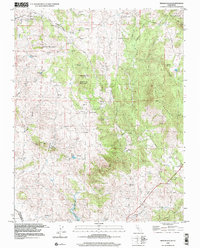
1999 Map of Indian Gulch
USGS Topo · Published 2002About this map
Indian Gulch serves as a focal point for this landscape in the western foothills of the Sierras, situated between the Merced and Mariposa county line. The map reveals a history of early mining and settlement, notably at the Toledo (Site) and the Indian Gulch Cem. Educational and spiritual life is anchored by the Hornitos Sch and St Marys Church, while the local economy is traced through numerous operations such as the Ruth Pierce Mine and the Domingas Mine. The terrain is defined by prominent rises like Quartz Mountain and Santa Cruz Mountain, which overlook the seasonal drainages of Burns Creek and Eldorado Creek. Southward, the geography shifts toward the Merced River Reservoir, where the landscape transitions from the high ridges of Shultz Mountain to the rolling ranchlands around Day Ranch.
Find a feature on this map
39 named features on this map. Tap any name to fly to it.
Don’t see what you’re looking for? This feature index may not catch every label — zoom into the map to look around manually.
Map Details
Editions of this 1999 Indian Gulch Map
This is the sole edition of this map. No revisions or reprints were ever made.
Other maps of this area

1893 · Sonora
USGS Topo · 1:125,000

1896 · Sonora
USGS Topo · 1:125,000

1897 · Sonora
USGS Topo · 1:125,000

1898 · Sonora
USGS Topo · 1:125,000

1915 · Owens Creek
USGS Topo · 1:31,680

1916 · Merced Falls
USGS Topo · 1:24,000

1918 · Owens Creek
USGS Topo · 1:31,680

1918 · Planada
USGS Topo · 1:31,680

1919 · Indian Gulch
USGS Topo · 1:48,000

1919 · Haystack Mountain
USGS Topo · 1:31,680