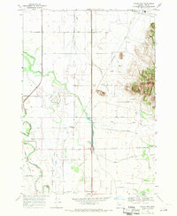
1969 Map of Indian Head
USGS Topo · Published 1971About this map
Indian Head rises as a prominent landmark on the eastern edge of this Willamette Valley landscape, overlooking a network of agricultural lands and meandering waterways during the late 1960s. The area is defined by the Southern Pacific rail line and a series of small rural communities, including Rowland and Priceboro. Local history is deeply etched into the terrain through family-named features like Wigle Cem, Blain Cem, and Harris Cem, alongside Harris Sch and the Grange Hall. Water dominates the drainage patterns here, with Little Muddy Creek and Spoon Creek threading through the flatlands, while Dinwiddie Valley and Twin Buttes provide vertical relief. The presence of several pipelines and a powerline crossing the valley reflects the mid-century modernization of rural Linn County infrastructure.
Find a feature on this map
37 named features on this map. Tap any name to fly to it.
Don’t see what you’re looking for? This feature index may not catch every label — zoom into the map to look around manually.
Map Details
Editions of this 1969 Indian Head Map
2 editions found
Other maps of this area

1909 · Harrisburg
USGS Topo · 1:31,680

1909 · Rowland
USGS Topo · 1:31,680

1910 · Eugene
USGS Topo · 1:62,500

1911 · Brownsville
USGS Topo · 1:31,680

1912 · Halsey
USGS Topo · 1:62,500

1921 · Brownsville
USGS Topo · 1:62,500

1940 · Eugene
USGS Topo · 1:62,500

1941 · Halsey
USGS Topo · 1:62,500

1946 · Eugene
USGS Topo · 1:62,500

1949 · Eugene
USGS Topo · 1:62,500