
1973 Map of Indian Meadows
USGS Topo · Published 1977About this map
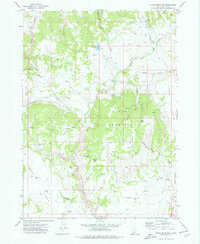
Indian Meadows defines the central character of this high-desert Owyhee County landscape, where water sources are the primary markers of human and animal activity. Surveyed in the early 1970s, the terrain is shaped by the North Fork Owyhee River and its intricate drainage network, including Current Creek and Nip and Tuck Creek. The distribution of named water sources like Surprise Spring, Big Boggy Spring, and Indian Meadows Spring reveals the essential infrastructure for ranching in this arid environment. A network of Pack Trails and Jeep Trails provides access through the complex topography of Combination Ridge and Riley Gulch, while a lone Corral near Noon Creek stands as a concrete indicator of the area's grazing history.
Find a feature on this map
24 named features on this map. Tap any name to fly to it.
Don’t see what you’re looking for? This feature index may not catch every label — zoom into the map to look around manually.
Map Details
Editions of this 1973 Indian Meadows Map
This is the sole edition of this map. No revisions or reprints were ever made.
Other maps of this area

1955 · Jordan Valley
USGS Topo · 1:250,000

1957 · Jordan Valley
USGS Topo · 1:250,000

1958 · Jordan Valley
USGS Topo · 1:250,000

1965 · Triangle
USGS Topo · 1:62,500

1965 · Flint Creek
USGS Topo · 1:62,500

1973 · Pleasant Valley
USGS Topo · 1:24,000

1973 · Wickiup Creek
USGS Topo · 1:24,000

1973 · Fairylawn
USGS Topo · 1:24,000

1973 · Cliffs
USGS Topo · 1:24,000
1973 · Slack Mountain
USGS Topo · 1:24,000