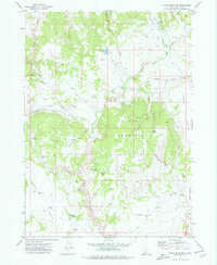
1973 Map of Slack Mountain
USGS Topo · Published 1977About this map
Slack Mountain anchors this high-desert Owyhee County landscape, where deep drainages like Cow Valley Canyon and Jackass Creek have carved a complex network of rimrock and plateaus. In the early 1970s, this area was defined by its vast grazing potential and water management, evidenced by numerous named reservoirs such as Nickel Res and Antelope Res. Large flat-topped mesas known as tables, including Avery Table, Boni Table, and Grass Table, dominate the topography, providing distinct landmarks for navigation.
Find a feature on this map
46 named features on this map. Tap any name to fly to it.
Don’t see what you’re looking for? This feature index may not catch every label — zoom into the map to look around manually.
Map Details
Editions of this 1973 Slack Mountain Map
This is the sole edition of this map. No revisions or reprints were ever made.
Other maps of this area

1955 · Jordan Valley
USGS Topo · 1:250,000

1957 · Jordan Valley
USGS Topo · 1:250,000

1958 · Jordan Valley
USGS Topo · 1:250,000
1973 · Wagon Box Basin
USGS Topo · 1:24,000

1973 · Smith Creek
USGS Topo · 1:24,000

1973 · Castro Table
USGS Topo · 1:24,000

1973 · Indian Meadows
USGS Topo · 1:24,000

1973 · Hurry Up Creek
USGS Topo · 1:24,000

1973 · Pleasant Valley
USGS Topo · 1:24,000

1973 · Wickiup Creek
USGS Topo · 1:24,000