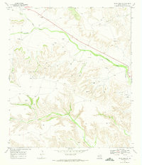
1969 Map of Indian Mesa SE
USGS Topo · Published 1973About this map
The rugged Pecos County landscape is defined by the sweeping course of Fourmile Draw and the prominent elevations of Indian Mesa. During the late 1960s, this region was a hub of energy production, evidenced by the extensive Priest Beavers Oil Field and numerous scattered oil wells and drill holes across the plateau. Ranching life persisted alongside this industrial development, with family operations like the Jeff Owens Ranch, Claude Owens Ranch, and Perry Ranch situated in the winding draws and atop the mesas.
Find a feature on this map
18 named features on this map. Tap any name to fly to it.
Don’t see what you’re looking for? This feature index may not catch every label — zoom into the map to look around manually.
Map Details
Editions of this 1969 Indian Mesa SE Map
This is the sole edition of this map. No revisions or reprints were ever made.
Other maps of this area

1929 · Sheffield
USGS Topo · 1:125,000

1929 · Independence Draw Quadrangle
USGS Topo · 1:125,000

1954 · Fort Stockton
USGS Topo · 1:250,000

1954 · Sonora
USGS Topo · 1:250,000

1958 · Sonora
USGS Topo · 1:250,000

1958 · Fort Stockton
USGS Topo · 1:250,000

1967 · Divide Country
USGS Topo · 1:24,000

1967 · Sheffield NW
USGS Topo · 1:24,000
1967 · Iraan
USGS Topo · 1:24,000
1969 · Smoky Mountain Ranch
USGS Topo · 1:24,000