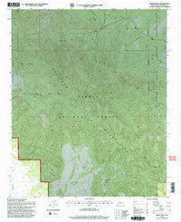
1995 Map of Indian Mesa
USGS Topo · Published 1998About this map
The Alamo Indian Reservation Boundary defines the eastern edge of this high-desert landscape in Socorro County. Dominated by the soaring peaks of the Gallinas Mountains, the area is largely contained within the Cibola National Forest. This 1995 revision provides a detailed look at the resource-dependent infrastructure of the era, where water management is critical for survival and land use. Isolated outposts like the Baca Homestead and features such as the High Lonesome Windmill and Long West Windmill speak to the history of ranching and settlement in this arid terrain.
Find a feature on this map
22 named features on this map. Tap any name to fly to it.
Don’t see what you’re looking for? This feature index may not catch every label — zoom into the map to look around manually.
Map Details
Editions of this 1995 Indian Mesa Map
This is the sole edition of this map. No revisions or reprints were ever made.
Other maps of this area

1954 · Socorro
USGS Topo · 1:250,000

1958 · Socorro
USGS Topo · 1:250,000

1962 · Socorro
USGS Topo · 1:250,000

1964 · Indian Mesa
USGS Topo · 1:24,000

1964 · Table Mountain
USGS Topo · 1:24,000

1964 · Dog Springs
USGS Topo · 1:24,000

1964 · Gallinas Peak
USGS Topo · 1:24,000

1964 · Puertecito
USGS Topo · 1:24,000

1964 · Lion Mountain
USGS Topo · 1:24,000
1964 · Indian Spring Canyon
USGS Topo · 1:24,000