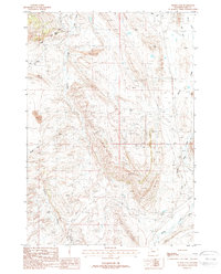
1987 Map of Indian Pass
USGS Topo · Published 1988About this map
The rugged Wyoming landscape near Indian Pass is defined by a dense network of industrial and irrigation infrastructure in this late 1980s record. Extensive water management systems like the Cody Canal and Lakeview Ditch underscore the area's agricultural development, while the energy sector is represented by the Half Moon Oil Field and numerous utilities, including a Substation and prominent Trans Line. Resource extraction is evident through the presence of an Open Pit Mine, Gravel Pit, and localized Tailings deposits.
Find a feature on this map
15 named features on this map. Tap any name to fly to it.
Don’t see what you’re looking for? This feature index may not catch every label — zoom into the map to look around manually.
Map Details
Editions of this 1987 Indian Pass Map
This is the sole edition of this map. No revisions or reprints were ever made.
Other maps of this area

1911 · Oregon Basin
USGS Topo · 1:62,500

1913 · Oregon Basin
USGS Topo · 1:62,500

1949 · Cody
USGS Topo · 1:62,500

1951 · Cody
USGS Topo · 1:62,500

1955 · Cody
USGS Topo · 1:250,000

1957 · Devils Tooth
USGS Topo · 1:62,500

1958 · Cody
USGS Topo · 1:250,000

1962 · Cody
USGS Topo · 1:250,000

1966 · Corbett Dam
USGS Topo · 1:24,000

1980 · Carter Mountain
USGS Topo · 1:100,000