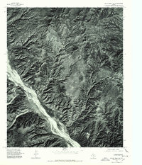
1976 Map of Indian Peak NW
USGS Topo · Published 1978About this map
Prairie Dog Town Fork Red River snakes through the deep canyons and broken breaks of this West Texas landscape, captured in a detailed 1976 orthophotograph. This specific aerial perspective emphasizes the stark geological transitions between the high plains and the eroded river valley, where water action has carved intricate drainages into the Caprock. While the terrain is largely uninhabited, the presence of Mitchell Park suggests the utilization of the more level plateau areas above the river's path. Unlike standard topographic sheets, this orthophotoquad provides a direct visual record of the vegetation patterns and soil exposures during the mid-1970s, making it a critical resource for understanding the land use and natural erosion patterns along this significant branch of the Red River.
Find a feature on this map
2 named features on this map. Tap any name to fly to it.
Don’t see what you’re looking for? This feature index may not catch every label — zoom into the map to look around manually.
Map Details
Editions of this 1976 Indian Peak NW Map
This is the sole edition of this map. No revisions or reprints were ever made.
Other maps of this area

1954 · Plainview
USGS Topo · 1:250,000

1958 · Plainview
USGS Topo · 1:250,000

1960 · Indian Peak
USGS Topo · 1:62,500

1963 · Paloduro
USGS Topo · 1:24,000

1963 · Tate Arroyo
USGS Topo · 1:24,000
1963 · Gip Creek
USGS Topo · 1:24,000

1965 · Ross Canyon
USGS Topo · 1:24,000

1965 · Big Betty Reservoir
USGS Topo · 1:24,000
1976 · Indian Peak SW
USGS Topo · 1:24,000
1976 · Indian Peak NE
USGS Topo · 1:24,000