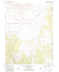
1993 Map of Indian Peaks
USGS Topo · Published 1993About this map
The Pony Express and Overland Stage Route cuts a historical corridor across this landscape, tracing the northern edge of the Simpson Mountains and the arid reaches of Skull Valley. This 1993 revision, based on surveys dating back to 1953, details a high-desert environment where water sources like Winter Springs and Tom's Spring were vital for both historic travelers and the livestock at James Ranch. The terrain transitions from the dramatic rises of Davis Mountain and the Indian Peaks into the timbered drainage of the Wasatch National Forest. A network of intermittent drainages, including Government Creek and its canyon systems like Log Canyon, illustrates the complex hydrology of the Great Basin, where seasonal flows define the viability of ranching and transit.
Find a feature on this map
17 named features on this map. Tap any name to fly to it.
Don’t see what you’re looking for? This feature index may not catch every label — zoom into the map to look around manually.
Map Details
Editions of this 1993 Indian Peaks Map
This is the sole edition of this map. No revisions or reprints were ever made.
Other maps of this area

1885 · Sevier Desert
USGS Topo · 1:250,000

1885 · Tooele Valley
USGS Topo · 1:250,000

1953 · Tooele
USGS Topo · 1:250,000

1953 · Delta
USGS Topo · 1:250,000

1955 · Simpson Springs
USGS Topo · 1:24,000

1955 · Indian Peaks
USGS Topo · 1:24,000

1955 · Indian Springs
USGS Topo · 1:24,000

1955 · Camels Back Ridge NE
USGS Topo · 1:24,000

1955 · Davis Knolls
USGS Topo · 1:24,000

1955 · Coyote Springs
USGS Topo · 1:24,000