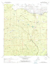
1976 Map of Indian Pine
USGS Topo · Published 1977About this map
The Mogollon Rim drops sharply through the center of this 1970s survey, marking the transition from the high plateau of the Sitgreaves National Forest into the deeply incised canyons of the Fort Apache Indian Reservation. Settlements like Pinetop and the Hon Dah Homesite are clustered near the northern edge, where the Pinetop Lakes Country Club and Rodeo Grounds reflect the area's mid-century recreational development.
Find a feature on this map
76 named features on this map. Tap any name to fly to it.
Don’t see what you’re looking for? This feature index may not catch every label — zoom into the map to look around manually.
Map Details
Editions of this 1976 Indian Pine Map
This is the sole edition of this map. No revisions or reprints were ever made.
Other maps of this area

1886 · St Johns
USGS Topo · 1:250,000

1886 · Holbrook
USGS Topo · 1:250,000

1892 · St Johns
USGS Topo · 1:250,000

1893 · Holbrook
USGS Topo · 1:250,000

1954 · Holbrook
USGS Topo · 1:250,000

1954 · Clifton
USGS Topo · 1:250,000

1954 · Saint Johns
USGS Topo · 1:250,000

1954 · Mesa
USGS Topo · 1:250,000

1957 · Mesa
USGS Topo · 1:250,000

1957 · Holbrook
USGS Topo · 1:250,000