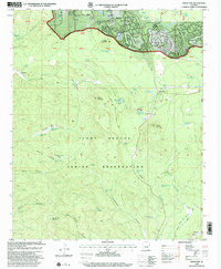
1998 Map of Indian Pine
USGS Topo · Published 2000About this map
Sitgreaves National Forest and the Fort Apache Indian Reservation meet across this high-country landscape, where the northern rim gives way to a complex system of deep canyons. The settlement of Pinetop and its surrounding recreational facilities, including the White Mountain Country Club and Pinetop Lakes Country Club, represent the developed northern edge of the map. South of the Rim Road, the terrain becomes significantly more primitive, defined by the systematic series of First Hollow through Fourth Hollow.
Find a feature on this map
85 named features on this map. Tap any name to fly to it.
Don’t see what you’re looking for? This feature index may not catch every label — zoom into the map to look around manually.
Map Details
Editions of this 1998 Indian Pine Map
This is the sole edition of this map. No revisions or reprints were ever made.
Other maps of this area

1886 · St Johns
USGS Topo · 1:250,000

1886 · Holbrook
USGS Topo · 1:250,000

1892 · St Johns
USGS Topo · 1:250,000

1893 · Holbrook
USGS Topo · 1:250,000

1954 · Holbrook
USGS Topo · 1:250,000

1954 · Clifton
USGS Topo · 1:250,000

1954 · Saint Johns
USGS Topo · 1:250,000

1954 · Mesa
USGS Topo · 1:250,000

1957 · Mesa
USGS Topo · 1:250,000

1957 · Holbrook
USGS Topo · 1:250,000