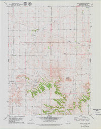
1979 Map of Indian Springs
USGS Topo · Published 1979About this map
Indian Springs and the surrounding high plains of Banner County are captured here in the late 1970s, showcasing a landscape defined by isolated ranching operations and distinctive landforms. The terrain transitions from the relatively level northern plains near Pumpkin Cr to the more dramatic elevations of Table Top Mountain and Bighorn Mountain in the south. These topographic features are dissected by Bighorn Gulch and various canyons, illustrating the erosional character of the region.
Find a feature on this map
15 named features on this map. Tap any name to fly to it.
Don’t see what you’re looking for? This feature index may not catch every label — zoom into the map to look around manually.
Map Details
Editions of this 1979 Indian Springs Map
This is the sole edition of this map. No revisions or reprints were ever made.
Other maps of this area

1898 · Scotts Bluff
USGS Topo · 1:125,000

1898 · Camp Clarke
USGS Topo · 1:125,000

1954 · Scottsbluff
USGS Topo · 1:250,000

1958 · Scottsbluff
USGS Topo · 1:250,000

1965 · McGrew
USGS Topo · 1:24,000

1973 · Scotts Bluff 4 NW
USGS Topo · 1:24,000

1973 · Scotts Bluff 4 SE
USGS Topo · 1:24,000

1973 · Scotts Bluff 4 NE
USGS Topo · 1:24,000

1973 · Scotts Bluff 4 SW
USGS Topo · 1:24,000

1973 · Kimball 1 NE
USGS Topo · 1:24,000