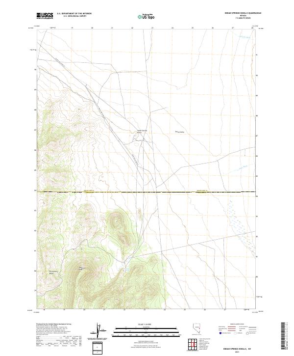
2021 Map of Indian Springs Knolls
USGS Topo · Published 2021About this map
Fortification Range and the high point of Patterson Peak anchor the western edge of this Nevada landscape, where the mountainous terrain gives way to the broad expanse of Spring Valley. The map highlights a remote section of the high desert along the White Pine and Lincoln County line, a region defined by its hydrographic patterns and land management divisions. The White Pine Co Road 47 traverses the flats near the Indian Springs Knolls, following the natural drainage routes toward Murphy Wash and Johns Wash. This 2021 edition provides a clear picture of modern land navigation and topography in a sparsely populated area, useful for researchers tracking land ownership patterns or geographical landmarks in the Great Basin.
Find a feature on this map
12 named features on this map. Tap any name to fly to it.
Don’t see what you’re looking for? This feature index may not catch every label — zoom into the map to look around manually.
Map Details
Editions of this 2021 Indian Springs Knolls Map
This is the sole edition of this map. No revisions or reprints were ever made.
Other maps of this area

1948 · Wheeler Peak
USGS Topo · 1:62,500

1950 · Wheeler Peak
USGS Topo · 1:62,500

1956 · Lund
USGS Topo · 1:250,000

1960 · Lund
USGS Topo · 1:250,000

1973 · Gouge Eye Well
USGS Topo · 1:24,000

1973 · Indian Springs Knolls
USGS Topo · 1:24,000
1973 · Mount Grafton NE
USGS Topo · 1:24,000

1973 · Red Ledges
USGS Topo · 1:24,000
1973 · Wells Summit
USGS Topo · 1:24,000
1978 · The Gouge Eye
USGS Topo · 1:24,000