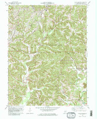
1978 Map of Indian Springs
USGS Topo · Published 1978About this map
The U S Naval Reservation Weapons Support Center dominates the central landscape of this Martin County region, illustrating the significant military footprint in southern Indiana during the late twentieth century. This federal installation bisects the townships of Perry and Mitcheltree, surrounding the valley of Boggs Creek. The map serves as a vital resource for genealogists, documenting numerous family and community burial sites such as Salem Cem, Waggoner Cem, and Little Hickory Ridge Cem.
Find a feature on this map
32 named features on this map. Tap any name to fly to it.
Don’t see what you’re looking for? This feature index may not catch every label — zoom into the map to look around manually.
Map Details
Editions of this 1978 Indian Springs Map
2 editions found
Other maps of this area

1935 · Oolitic
USGS Topo · 1:48,000

1942 · Oolitic
USGS Topo · 1:62,500

1948 · Huron
USGS Topo · 1:24,000

1950 · Huron
USGS Topo · 1:24,000

1950 · Shoals
USGS Topo · 1:24,000

1950 · Odon
USGS Topo · 1:24,000

1956 · Loogootee
USGS Topo · 1:24,000

1956 · Koleen
USGS Topo · 1:24,000

1956 · Indian Springs
USGS Topo · 1:24,000

1956 · Vincennes
USGS Topo · 1:250,000