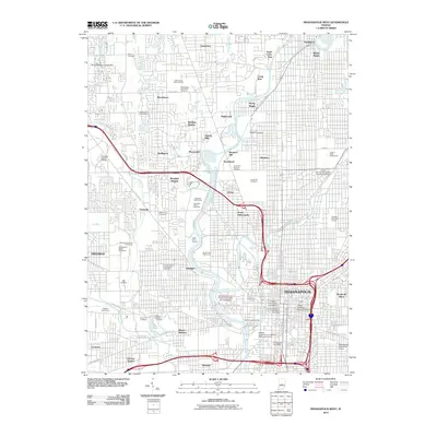
2010 Map of Indianapolis West
USGS Topo · Published 2010About this map
The White River and Fall Creek converge near the heart of the Indiana state capital, anchoring a dense network of neighborhoods and historic institutions. Central to the landscape is the sprawling Indianapolis Motor Speedway, famously home to the Brickyard Crossing Golf Course, while the Indiana State Fairgrounds occupies the northeastern reaches. Educational and cultural hubs are prominent, including the riverside campus of Butler University and the Indiana University-Purdue University at Indianapolis grounds. Large burial grounds like Crown Hill Cemetery and Floral Park Cemetery provide expansive green spaces among the residential grids of Broad Ripple, Woodruff Place, and North Indianapolis. This era captures a fully developed urban infrastructure, where recreational sites like the Soap Box Derby Racetrack sit alongside major aviation facilities such as the Indianapolis Downtown Airport.
Find a feature on this map
95 named features on this map. Tap any name to fly to it.
Don’t see what you’re looking for? This feature index may not catch every label — zoom into the map to look around manually.
Map Details
Editions of this 2010 Indianapolis West Map
This is the sole edition of this map. No revisions or reprints were ever made.
Other maps of this area

1948 · Indianapolis East
USGS Topo · 1:24,000

1948 · Maywood
USGS Topo · 1:24,000

1948 · Beech Grove
USGS Topo · 1:24,000

1948 · Indianapolis West
USGS Topo · 1:24,000

1952 · Fishers
USGS Topo · 1:24,000

1952 · Carmel
USGS Topo · 1:24,000

1953 · Bridgeport
USGS Topo · 1:24,000

1953 · Zionsville
USGS Topo · 1:24,000

1953 · Clermont
USGS Topo · 1:24,000

1953 · Indianapolis
USGS Topo · 1:250,000
Featured Places
- Indianapolis, IN
- Speedway, Indianapolis
- Meridian Hills, Indianapolis
- Rocky Ripple, Indianapolis
- Wynnedale, Indianapolis