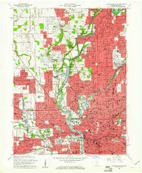
1959 Map of Indianapolis West
USGS Topo · Published 1961About this map
The Indianapolis Motor Speedway and the expansive grounds of Crown Hill Cemetery anchor this mid-century portrait of the city's west side. During this era of post-war expansion, the urban fabric of Indianapolis pushes outward into residential enclaves like Broadmoor, Knollton Heights, and Eagledale. The White River winds through the center of the sheet, flanked by numerous recreational and institutional landmarks, including Butler University and the State Fish Hatchery. The map captures a dense network of social infrastructure, from the Central State Hospital Colony to the concentrated complex of the Indiana University Medical Center. The city's industrial and logistical backbone is clearly visible through the rail corridors of the Pennsylvania Railroad and Baltimore and Ohio Railroad, which converge near Union Sta and the civic heart of the State Capitol.
Find a feature on this map
86 named features on this map. Tap any name to fly to it.
Don’t see what you’re looking for? This feature index may not catch every label — zoom into the map to look around manually.
Map Details
Editions of this 1959 Indianapolis West Map
This is the sole edition of this map. No revisions or reprints were ever made.
Other maps of this area

1948 · Indianapolis East
USGS Topo · 1:24,000

1948 · Maywood
USGS Topo · 1:24,000

1948 · Beech Grove
USGS Topo · 1:24,000

1948 · Indianapolis West
USGS Topo · 1:24,000

1952 · Fishers
USGS Topo · 1:24,000

1952 · Carmel
USGS Topo · 1:24,000

1953 · Bridgeport
USGS Topo · 1:24,000

1953 · Zionsville
USGS Topo · 1:24,000

1953 · Clermont
USGS Topo · 1:24,000

1953 · Indianapolis
USGS Topo · 1:250,000
Featured Places
- Indianapolis, IN
- Speedway, Indianapolis
- Meridian Hills, Indianapolis
- Rocky Ripple, Indianapolis
- Wynnedale, Indianapolis