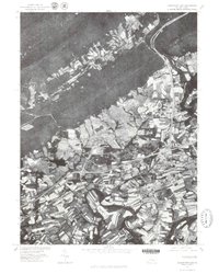
1977 Map of Indiantown Gap
USGS Topo · Published 1979About this map
Indiantown Gap serves as the focal point of this 1970s orthophotograph, where the dense woodland of the Appalachian ridges meets the developing valley of northern Lebanon County. The imagery, produced by the Geological Survey in cooperation with the Soil Conservation Service, provides a detailed visual of the land use patterns surrounding the gap. Small crossroads settlements like Harper Tavern, Ono, and Bordnersville are clearly visible, tucked between expansive agricultural fields and the burgeoning interstate highway corridors. To the west, the waters of State Memorial Lake stand out against the terrain, while the parallel ridges of Blue Mountain, Second Mountain, and Sharp Mountain dominate the northern landscape. This perspective captured in 1977 documents the transition from traditional rural farmsteads to a modern transportation hub near Lickdale.
Find a feature on this map
9 named features on this map. Tap any name to fly to it.
Don’t see what you’re looking for? This feature index may not catch every label — zoom into the map to look around manually.
Map Details
Editions of this 1977 Indiantown Gap Map
This is the sole edition of this map. No revisions or reprints were ever made.
Other maps of this area

1891 · Lebanon
USGS Topo · 1:62,500

1892 · Lykens
USGS Topo · 1:62,500

1892 · Hummelstown
USGS Topo · 1:62,500

1892 · Pine Grove
USGS Topo · 1:62,500

1893 · Lykens
USGS Topo · 1:62,500

1893 · Lebanon
USGS Topo · 1:62,500

1899 · Lebanon
USGS Topo · 1:62,500

1924 · Hummelstown
USGS Topo · 1:62,500

1943 · Lebanon
USGS Topo · 1:62,500

1943 · Lykens
USGS Topo · 1:62,500
Featured Places
- East Hanover Township, PA
- Union Township, PA
- Swatara Township, PA
- McGillstown, East Hanover Township
- Indiantown, East Hanover Township