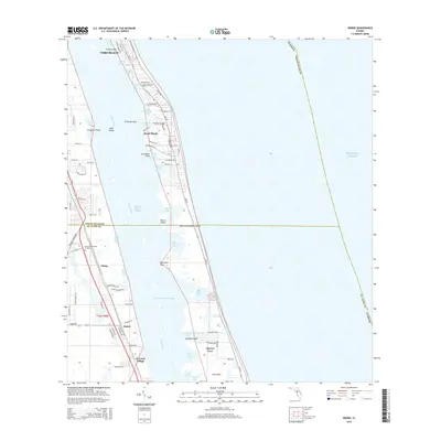
2015 Map of Indrio
USGS Topo · Published 2015About this map
Vero Beach and the shoreline of the Indian River Lagoon anchor this 2015 study of the Florida Atlantic coast. The map illustrates a landscape defined by the intricate boundary between mainland developments and the barrier island system. Inland, the community of Indrio and the Hillcrest Memorial Gardens are situated near the Indian River County and St. Lucie County line. The coastal geography is marked by numerous small islands and tidal features, including Shell Island, Round Island, and the complex network of Big Starvation Cove. Further south, the residential and maritime character of the region is evident in settlements like Viking, St. Lucie Village, and the canal-lined neighborhood of Queens Cove. The Intracoastal Waterway cuts through the lagoon, providing a vital artery for navigation alongside the expansive Atlantic Ocean coastline.
Find a feature on this map
86 named features on this map. Tap any name to fly to it.
Don’t see what you’re looking for? This feature index may not catch every label — zoom into the map to look around manually.
Map Details
Editions of this 2015 Indrio Map
This is the sole edition of this map. No revisions or reprints were ever made.
Other maps of this area

1948 · Riomar
USGS Topo · 1:24,000

1948 · Indrio
USGS Topo · 1:24,000

1949 · Fort Pierce
USGS Topo · 1:24,000

1949 · Vero Beach
USGS Topo · 1:24,000

1949 · Oslo
USGS Topo · 1:24,000

1949 · Fort Pierce NW
USGS Topo · 1:24,000

1950 · Riomar
USGS Topo · 1:24,000

1950 · Fort Pierce
USGS Topo · 1:24,000

1950 · Fort Pierce NW
USGS Topo · 1:24,000

1950 · Oslo
USGS Topo · 1:24,000