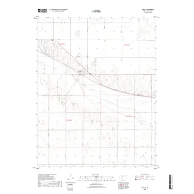
2018 Map of Ingalls
USGS Topo · Published 2018About this map
Ingalls sits along the northern bank of the Arkansas River, serving as a central hub for the surrounding agricultural sections of Gray County. This 2018 survey illustrates a landscape defined by the geometric precision of the Public Land Survey System, with a dense network of county roads such as Co Rd 12 and Co Rd 13 creating a patchwork of fertile plains. To the northwest of the main town site, the Ingalls- Logan Cem provides a focal point for genealogical research, situated near the intersection of L Rd and Co Rd 12. The presence of Soule Ave within the town grid marks the historical development of the local infrastructure. Beyond the river corridor, the terrain transitions into more varied topography, particularly south of the river within t26s r29w and t26s r28w, where ephemeral water features and subtle elevation changes become more prominent.
Find a feature on this map
24 named features on this map. Tap any name to fly to it.
Don’t see what you’re looking for? This feature index may not catch every label — zoom into the map to look around manually.
Map Details
Editions of this 2018 Ingalls Map
This is the sole edition of this map. No revisions or reprints were ever made.
Other maps of this area
1892 · Dodge
USGS Topo · 1:125,000
1896 · Garden
USGS Topo · 1:125,000
1955 · Dodge City
USGS Topo · 1:250,000
1958 · Dodge City
USGS Topo · 1:250,000
1959 · Dodge City
USGS Topo · 1:250,000
1968 · Cimarron NW
USGS Topo · 1:24,000
1968 · Ingalls
USGS Topo · 1:24,000
1968 · Montezuma NW
USGS Topo · 1:24,000
1968 · Cimarron
USGS Topo · 1:24,000
1968 · Cimarron NE
USGS Topo · 1:24,000