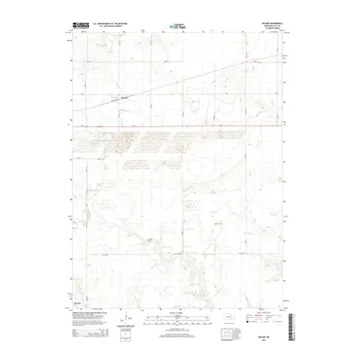
2014 Map of Inland
USGS Topo · Published 2014About this map
Inland and Glenvil anchor this 2014 survey of central Nebraska, illustrating a landscape defined by an orderly grid of section roads and the persistent drainage patterns of the Great Plains. The map details a primarily agricultural environment where the built environment follows the corridors of Us-6 and the NE-18-Spur. Waterways like School Cr and Little Sandy Cr wind through the township sections, creating subtle breaks in the surveyed fields. Local history is anchored by the presence of Zion Cem and Glenvil Cem, which serve as permanent markers of early settlement families. The extensive network of numbered roads, including Road 44 and Road 36, provides a clear view of the rural infrastructure connecting these small communities during the early 21st century.
Find a feature on this map
21 named features on this map. Tap any name to fly to it.
Don’t see what you’re looking for? This feature index may not catch every label — zoom into the map to look around manually.
Map Details
Editions of this 2014 Inland Map
This is the sole edition of this map. No revisions or reprints were ever made.
Other maps of this area

1898 · Superior
USGS Topo · 1:125,000

1898 · Grand Island
USGS Topo · 1:125,000

1955 · Grand Island
USGS Topo · 1:250,000

1957 · Grand Island
USGS Topo · 1:250,000

1958 · Grand Island
USGS Topo · 1:250,000

1969 · Hastings East
USGS Topo · 1:24,000

1969 · Fairfield NW
USGS Topo · 1:24,000
1969 · Trumbull
USGS Topo · 1:24,000
1969 · Fairfield
USGS Topo · 1:24,000
1969 · Harvard NE
USGS Topo · 1:24,000