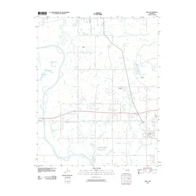
2010 Map of Inola
USGS Topo · Published 2010About this map
The town of Inola serves as the focal point of this Rogers County landscape, situated where the prairie meets the intricate drainage systems of the Verdigris River. This 2010 survey illustrates a region defined by its water management and aviation history, featuring numerous oxbow lakes such as Horseshoe Lake, Little Flag Lake, and Big Flag Lake that mark the river's winding course. Smaller tributaries like Commodore Creek and Salt Creek feed into the main waterway, while the Oknoname 131006 Reservoir and Inola Lake represent more modern water control efforts. For local historians, the Sweeten Cemetery provides a tangible link to the area's early residents. The local economy and transportation network are further highlighted by specialized landmarks like Night Hawk Airpatch, Dobies Airport, and Gilstrap Field, reflecting a rural Oklahoma community integrated with private aviation and agricultural infrastructure.
Find a feature on this map
36 named features on this map. Tap any name to fly to it.
Don’t see what you’re looking for? This feature index may not catch every label — zoom into the map to look around manually.
Map Details
Editions of this 2010 Inola Map
This is the sole edition of this map. No revisions or reprints were ever made.
Other maps of this area

1896 · Pryor
USGS Topo · 1:125,000

1901 · Claremore
USGS Topo · 1:125,000

1901 · Pryor
USGS Topo · 1:125,000

1914 · Claremore
USGS Topo · 1:125,000

1916 · Claremore
USGS Topo · 1:125,000

1954 · Tulsa
USGS Topo · 1:250,000

1958 · Tulsa
USGS Topo · 1:250,000

1963 · Tulsa
USGS Topo · 1:250,000
1963 · Neodesha
USGS Topo · 1:24,000
1963 · Oneta
USGS Topo · 1:24,000