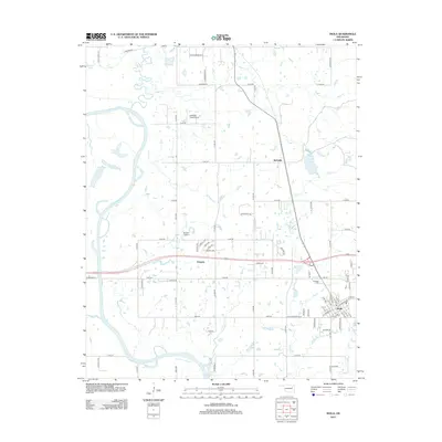
2013 Map of Inola
USGS Topo · Published 2013About this map
The Verdigris River snakes through this Rogers County landscape, defining the western edge of the area as it passes Horseshoe Lake and Little Flag Lake. In the eastern half of the quadrangle, the town of Inola serves as a central hub, connected to the smaller settlements of Gregory and McFarlin by a network of rural roads. The terrain is characterized by numerous small water bodies and seasonal drainages like Otter Cr and Inola Cr, which feed into the larger river system. Local aviation history is represented by Gilstrap Field Airport and Dobie's Airport, while the Sweeten Cem north of the main town provides a point of interest for genealogists. The map details a transition from the riparian environment of the river bottomlands to the organized agricultural plots and growing residential pockets of the Oklahoma plains.
Find a feature on this map
81 named features on this map. Tap any name to fly to it.
Don’t see what you’re looking for? This feature index may not catch every label — zoom into the map to look around manually.
Map Details
Editions of this 2013 Inola Map
This is the sole edition of this map. No revisions or reprints were ever made.
Other maps of this area

1896 · Pryor
USGS Topo · 1:125,000

1901 · Claremore
USGS Topo · 1:125,000

1901 · Pryor
USGS Topo · 1:125,000

1914 · Claremore
USGS Topo · 1:125,000

1916 · Claremore
USGS Topo · 1:125,000

1954 · Tulsa
USGS Topo · 1:250,000

1958 · Tulsa
USGS Topo · 1:250,000

1963 · Tulsa
USGS Topo · 1:250,000
1963 · Neodesha
USGS Topo · 1:24,000
1963 · Oneta
USGS Topo · 1:24,000