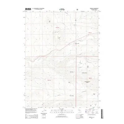
2015 Map of Inskip Hill
USGS Topo · Published 2015About this map
Paynes Creek serves as a central landmark in this portion of Tehama County, where the volcanic topography of the southern Cascade Range meets the Sacramento Valley foothills. The map reveals a landscape defined by distinctive cinder cones and volcanic features, most notably the prominent Inskip Hill and its neighbor, Little Inskip Hill. These summits overlook a series of family-named locales such as Wade Place, McKenzie Place, and Meyers Place, which highlight the area's history of rural homesteads and ranching. The eastern portion of the quadrangle transitions into the protected lands of Lassen National Forest, characterized by the steep drainage of De Haven Gulch and the elevation of Plum Creek Ridge. A network of unpaved tracks, including Hogsback Rd and Plum Creek Rd, provides access across the complex terrain of ridges and flats like Durley Flat.
Find a feature on this map
33 named features on this map. Tap any name to fly to it.
Don’t see what you’re looking for? This feature index may not catch every label — zoom into the map to look around manually.
Map Details
Editions of this 2015 Inskip Hill Map
This is the sole edition of this map. No revisions or reprints were ever made.
Other maps of this area

1886 · Lassen Peak
USGS Topo · 1:250,000

1890 · Red Bluff
USGS Topo · 1:250,000

1892 · Lassen Peak
USGS Topo · 1:250,000

1894 · Lassen Peak
USGS Topo · 1:250,000

1894 · Red Bluff
USGS Topo · 1:250,000

1905 · Tehama
USGS Topo · 1:62,500

1935 · Paynes Creek
USGS Topo · 1:96,000

1941 · Mineral
USGS Topo · 1:125,000

1944 · Tuscan Buttes
USGS Topo · 1:62,500

1947 · Tuscan Buttes
USGS Topo · 1:62,500