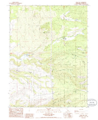
1985 Map of Inskip Hill
USGS Topo · Published 1985About this map
Inskip Hill and its neighboring Little Inskip Hill dominate this volcanic landscape in northeastern Tehama County, where the terrain is marked by cinder cones and lava flows. The settlement of Paynes Creek serves as a central point along the winding road through the hills, while smaller locales like De Haven and Meeker are scattered across the surrounding slopes. The map reveals a land utilized for both recreation and resource management, containing the Tehama State Wildlife Area and a portion of the Lassen National Forest. Local industry and infrastructure are represented by the Mt Lassen Trout Farm, various quarries, and the Inskip Lookout Tower perched atop the high ground. Notable geological and ranching features include the Inskip Caves and the Childs Ranch, illustrating the intersection of the region's unique subterranean features with its long-standing pastoral history.
Find a feature on this map
28 named features on this map. Tap any name to fly to it.
Don’t see what you’re looking for? This feature index may not catch every label — zoom into the map to look around manually.
Map Details
Editions of this 1985 Inskip Hill Map
2 editions found
Other maps of this area

1886 · Lassen Peak
USGS Topo · 1:250,000

1890 · Red Bluff
USGS Topo · 1:250,000

1892 · Lassen Peak
USGS Topo · 1:250,000

1894 · Lassen Peak
USGS Topo · 1:250,000

1894 · Red Bluff
USGS Topo · 1:250,000

1905 · Tehama
USGS Topo · 1:62,500

1935 · Paynes Creek
USGS Topo · 1:96,000

1941 · Mineral
USGS Topo · 1:125,000

1944 · Tuscan Buttes
USGS Topo · 1:62,500

1947 · Tuscan Buttes
USGS Topo · 1:62,500