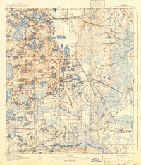
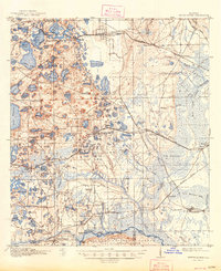
1916 Map of Interlachen
USGS Topo · Published 1941About this map
The lake-dotted landscape of Interlachen and western Putnam County is defined here by a dense concentration of sinkholes and wetlands during the early twentieth century. This 1915 survey shows a region reliant on rail and river transit, with the Atlantic Coast Line and the Georgia and Southern Road connecting settlements like Florahome, Melrose, and Hollister. To the south, the Oklawaha Valley reveals a riverfront economy where Jordans Ferry and Cedar Landing Ferry served as vital crossings. The presence of the Congo School and Roscola School provides localized landmarks for genealogical research, while the massive cypress swamps and prairies, such as Levy Prairie and The Slash, illustrate the difficult terrain that dictated early Florida settlement patterns and the growth of logging hamlets like Rodman.
Find a feature on this map
112 named features on this map. Tap any name to fly to it.
Don’t see what you’re looking for? This feature index may not catch every label — zoom into the map to look around manually.
Map Details
Editions of this 1916 Interlachen Map
6 editions found
Other maps of this area

1893 · Citra
USGS Topo · 1:62,500

1895 · Citra
USGS Topo · 1:62,500

1912 · Palatka
USGS Topo · 1:48,000

1915 · Palatka
USGS Topo · 1:62,500

1915 · Interlachen
USGS Topo · 1:48,000

1916 · Interlachen
USGS Topo · 1:62,500

1938 · Hawthorn
USGS Topo · 1:48,000

1941 · Starke
USGS Topo · 1:62,500

1942 · Ates Creek
USGS Topo · 1:62,500

1943 · Hawthorn
USGS Topo · 1:62,500