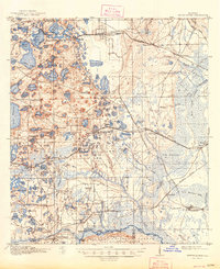
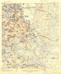
1916 Map of Interlachen
USGS Topo · Published 1948About this map
Interlachen sits at the heart of this lake-strewn landscape in the early twentieth century, serving as a hub where the Atlantic Coast Line meets local life. The terrain is defined by a dense network of water bodies, from the large Lake Grandin and Swan Lake to smaller features like Lady Slipper Lake and Devils Den. This era shows a transit-dependent economy, with the Georgia Southern and Florida railroad cutting through Florahome and Grandin while the Oklawaha Valley line serves the southeastern timber and agricultural corridor.
Find a feature on this map
114 named features on this map. Tap any name to fly to it.
Don’t see what you’re looking for? This feature index may not catch every label — zoom into the map to look around manually.
Map Details
Editions of this 1916 Interlachen Map
6 editions found
Other maps of this area

1893 · Citra
USGS Topo · 1:62,500

1895 · Citra
USGS Topo · 1:62,500

1912 · Palatka
USGS Topo · 1:48,000

1915 · Palatka
USGS Topo · 1:62,500

1915 · Interlachen
USGS Topo · 1:48,000

1916 · Interlachen
USGS Topo · 1:62,500

1938 · Hawthorn
USGS Topo · 1:48,000

1941 · Starke
USGS Topo · 1:62,500

1942 · Ates Creek
USGS Topo · 1:62,500

1943 · Hawthorn
USGS Topo · 1:62,500