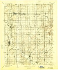
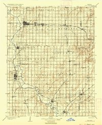
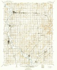
1904 Map of Iola
USGS Topo · Published 1924About this map
The Neosho River meanders south through the heart of Allen and Neosho counties, anchoring a landscape defined by its early 20th-century rail infrastructure and growing agricultural hubs. This 1902 survey, published in 1924, captures Iola and Chanute as primary rail junctions, where the Santa Fe R. R. and Missouri Pacific R. R. intersect with several other lines. The placement of the settlement named Gas and neighbor Laharpe reflect the regional industrial activity of the period. Smaller communities such as Savonburg, Stark, and St. Paul are clearly established along these corridors, providing a detailed record for genealogists and local historians tracking the development of the Neosho Valley. Along the eastern edge, the headwaters of the Marmaton River and Walnut Creek drain toward Bourbon and Crawford counties, showing the transition from river bottomlands to the prairie uplands of Southeast Kansas.
Find a feature on this map
66 named features on this map. Tap any name to fly to it.
Don’t see what you’re looking for? This feature index may not catch every label — zoom into the map to look around manually.
Map Details
Editions of this 1904 Iola Map
4 editions found

Other maps of this area

1884 · Fort Scott
USGS Topo · 1:125,000

1885 · Burlington
USGS Topo · 1:125,000

1885 · Garnett
USGS Topo · 1:125,000

1886 · Fredonia
USGS Topo · 1:125,000

1886 · Joplin
USGS Topo · 1:125,000

1886 · Iola
USGS Topo · 1:125,000

1886 · Independence
USGS Topo · 1:125,000

1886 · Fort Scott
USGS Topo · 1:125,000

1886 · Parsons
USGS Topo · 1:125,000

1887 · Mound City
USGS Topo · 1:125,000