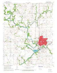
1966 Map of Iola
USGS Topo · Published 1967About this map
The Neosho River meanders through Allen County, defining the landscape around the industrial and agricultural hub of Iola. In the mid-1960s, the area's economy was anchored by transportation and natural resource extraction, evidenced by the numerous quarries and gravel pits flanking the riverbanks. Two major rail lines, the Atchison Topeka and Santa Fe and the Missouri Pacific, intersect within the city, facilitating the movement of goods from local industries and the neighboring community of Bassett.
Find a feature on this map
53 named features on this map. Tap any name to fly to it.
Don’t see what you’re looking for? This feature index may not catch every label — zoom into the map to look around manually.
Map Details
Editions of this 1966 Iola Map
2 editions found
Other maps of this area

1885 · Burlington
USGS Topo · 1:125,000

1885 · Garnett
USGS Topo · 1:125,000

1886 · Fredonia
USGS Topo · 1:125,000

1886 · Iola
USGS Topo · 1:125,000

1893 · Iola
USGS Topo · 1:125,000

1894 · Garnett
USGS Topo · 1:125,000

1894 · Fredonia
USGS Topo · 1:125,000

1894 · Burlington
USGS Topo · 1:125,000

1904 · Iola
USGS Topo · 1:125,000

1947 · Lawrence
USGS Topo · 1:250,000